Lewis and Clark at the Falls of the Ohio
This page is based on a brochure published in the summer of 2002 by the Falls of the Ohio Lewis and Clark Bicentennial Committee highlighting Lewis and Clark’s connections to the Falls of the Ohio area.
At the Falls of the Ohio in the summer of 1803, William Clark received a letter from Meriwether Lewis inviting him to help command an expedition to explore the Louisiana territory:
“Thus my friend … you have a summary view of the plan, the means and the objects of this expedition. If therefore there is anything under those circumstances, in this enterprise, which would induce you to participate with me in it’s fatiegues, it’s dangers and it’s honors, believe me there is no man on earth with whom I should feel equal pleasure in sharing them as with yourself.”
Lewis also asked Clark to:
“find out and engage some good hunters, stout, healthy, unmarried men, accustomed to the woods, and capable of bearing bodily fatigue in a pretty considerable degree: should any young men answering this description be found in your neighborhood I would thank you to give information of them on my arivall at the falls of the Ohio.”
So began the historic partnership of Lewis and Clark and the birth of the Corps of Discovery.
On October 14, 1803, Meriwether Lewis and William Clark met in Louisville, Kentucky, thus actually forming one of the most famous and successful partnerships in history. On October 26, 1803, Lewis and Clark, together with the nucleus of the Corps of Discovery, set off down the Ohio River from Clarksville, Indiana, on a journey that would take them to the Pacific Ocean and back.
With them went local recruits – handpicked by Clark – and Clark’s enslaved African American York. York became the first African American to cross the United States from coast to coast. The recruits Clark secured and the two that Lewis brought with him entered the annals of history as the “Nine Young Men from Kentucky.” These first permanent members made significant contributions toward the success of the endeavor. The men who met at and pushed off from the Falls in October 1803 formed one-third of the expedition’s permanent party. They formed the foundation for what historians describe as the most famous exploring venture in the history of America.
Two hundred years have passed since their departure to the west and return to the Falls of the Ohio in November 1806. The journey influenced the course of American history. The world has changed much in the two centuries since Lewis and Clark traversed the Falls area, but the legacy is still with us today. It is with us in the printed word, in institutional collections, and in landmarks. It is possible today to stand where the captains and the nucleus of the Corps of Discovery stood two hundred years ago; to visit where they visited; and to view expedition letters and artifacts. Explore the Falls of the Ohio and its Lewis and Clark legacy.
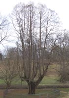
Mulberry Hill
Located in present-day George Rogers Clark Park, the Clark family homesite served as the residence of William Clark and York from 1785 to 1803. The outbuildings and the remains of the house were razed in 1917. The farm once included over three hundred acres and had two mills on the waters of Beargrass Creek. The family cemetery and a cypress tree dating to the Clarks’ residence are all that remain today.
- Location: George Rogers Clark Park, Poplar Level Road and Thruston Avenue, Louisville.
- Information: Metro Parks Department, 502-456-8100
- Directions: From I-264 take Poplar Level Road north. The park will be on the left. Turn left on Thruston, then left on Filson Avenue to park near the homesite and cemetery. From I-65 take Eastern Parkway east to Poplar Level, turn right, then right on Thruston, then left on Filson.
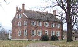
Locust Grove
A national historic landmark, the site was established by William Clark’s brother-in-law and sister, William and Lucy Clark Croghan, in 1790. Locust Grove was a stopping point for Meriwether Lewis and William Clark who were entertained here on November 8, 1806. It is the only known surviving Lewis and Clark structure west of the Appalachians. George Rogers Clark spent the last nine years of his life here, from 1809 until his death in 1818. The site also was home to numerous enslaved African Americans who lived and worked on the farm and contributed to its success. The site is on the Lewis and Clark National Historic Trail.
- Location: 561 Blankenbaker Lane, Louisville, KY 40207
- Information: 502-897-9845 / www.locustgrove.org
- Directions: From I-71 take Zorn Avenue north to River Road; River Road east to Blankenbaker Lane. From I-264 take Brownsboro Road (US 42) west, turn right on Blankenbaker Lane.
The Filson Historical Society
The Filson, Kentucky’s privately supported historical society, holds a nationally significant Lewis and Clark collection. Items include six expedition date letters written by William Clark and one by Meriwether Lewis; letters, a diary, and documents related to the expedition; a ca. 1817 portrait of Clark; and a bighorn sheep horn collected during the journey. Many historians believe this horn to be the only verified animal artifact from the expedition. Some of these items are on exhibit. The large “Lewis and Clark and the Exploration of the American West” exhibit that The Filson mounted in 2003-2004 will be at the Kentucky Historical Society‘s Thomas D. Clark Center for Kentucky History from October 2006 to January 2007. The Filson is a certified site on the Lewis and Clark National Historic Trail.
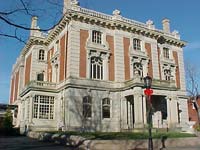
- Location: 1310 S. Third St., Louisville, KY 40208
- Information: 502-635-5083 / www.filsonhistorical.org
- Directions: From I-65 take the St. Catherine Street exit. Proceed west to Third Street. Turn left and go two blocks. The Filson is on the right.
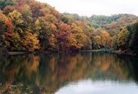
Jefferson County Memorial Forest
Located in southwestern Jefferson County, the Forest and surrounding area is where Joseph and Reubin Field grew up and became two of the best hunters on the expedition. Their home area stretches from Okolona in the east to Valley Station in the west, reflecting the location of the farms that the Field brothers grew up on and where Reubin lived after returning from the expedition. Areas of the forest resemble the country as it would have appeared during their day.
- Location: 11311 Mitchell Hill Road, Louisville, KY 40118
- Information: 502-368-5404, http://www.memorialforest.com
- Directions: From I-265 take the New Cut Road exit south. Proceed south on New Cut Road to Mitchell Hill Road. Follow that road about 2 miles to the welcome center.
West Point, Kentucky
Located at the mouth of Salt River, expedition blacksmith/gunsmith John Shields lived here when he joined the Corps of Discovery, apparently having recently moved from Jefferson County. Lewis comments that the party stopped at a Kentucky settlement a little below Louisville. This is believed to be West Point. Like the Field brothers, Shields received some of the highest praise from the captains for his contributions to the journey’s success. The place where Shields lived in West Point has been identified as being on Elm Street near Third Street. The nearby Young’s Inn dates from the period.

- Location: On the Ohio River about 20 miles southwest of Louisville.
- Information: West Point Visitor Center, 502-922-4260
- Directions: From I-265 or I-264 take US 31W south to West Point.
Louisville Waterfront near Fourth Street and Belvedere
It was most likely on the Louisville waterfront at the landing near Fourth Street that Lewis and Clark met on October 14, 1803, thus actually forming one of the greatest partnerships in history. Going back and forth between Louisville and Clarksville over the next twelve days, the captains prepared for their departure downriver. Today, the Belle of Louisville and other boats dock at this historic landing. Historical markers for the expedition, William Clark, and York mark the site. On the Belvedere is a statue of George Rogers Clark, founder of Louisville, by Felix de Weldon, and a statue of York by Ed Hamilton.
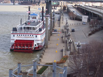
- Location: Waterfront at the Wharf, Belvedere and Waterfront Park
- Information: Louisville Visitor Information Center, 502-582-3732
- Directions: From downtown Louisville go north to River Road and turn into the wharf parking lot. River Road goes beneath I-64 in this area. You can walk to the wharf, park and Belvedere. You can walk directly to the Belvedere from Fifth and Main Streets.
Trough Spring
Built in 1802, under the supervision of William Clark, on a site selected by George Rogers Clark, Trough Spring was the home of Jonathan Clark. It was to his brother, and to this house, that William sent expedition date letters and artifacts. After the expedition and when William visited Louisville after his move to St. Louis in 1808, it was at Trough Spring that he often stayed. The house has significantly changed in appearance since the early 19th century but remains an important Lewis and Clark landmark. The house is a private residence and is not open for tours.
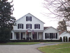
- Location: 1840 Trough Springs Lane, Louisville, KY
- Directions: From I-264 take Newburg Road north, right on Trevilian Way, right on Dundee Road, right on Trough Springs Lane.
Clarksville War Memorial
Located at the Clarksville Town Center, this memorial honors Clarksville, Indiana, citizens who died in the service of their country. Sgt. Charles Floyd of the expedition is the first listed. By the fall of 1799, the Floyd family had moved from Louisville across the river to Indiana. In 1801, Clark County was formed and Charles Floyd, at the young age of 18 or 19, was named the first constable of Clarksville Township. Two years later, Floyd was one of the first to be recruited by William Clark for the expedition. Floyd is buried in Sioux City, Iowa, near where he died on August 20, 1804.
- Location: 2000 Broadway, Clarksville, IN 47129
- Information: 812-288-7155 ext. 373
- Directions: From I-65 take exit 4 and go south on 131. Turn right at Green Tree Boulevard which becomes Veterans Parkway. Turn left on Broadway and right into the Town Center parking lot.
Little Flock Cemetery
This Harrison County, Indiana, the cemetery is believed to be the burial site of Private John Shields, who, at age 34, was the Corps of Discovery’s oldest enlisted member. His skills as blacksmith, gunsmith, and hunter were invaluable to the expedition’s success. After the expedition and upon his return to the Falls of the Ohio area, he settled near Corydon, perhaps being part of the Squire Boone (brother of the famous Daniel Boone) party that settled in the area. Shields died in December of 1809.
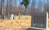
- Location: Rosewood Road, Taylor Township, Harrison County, Indiana
- Information: Harrison County Convention and Visitor’s Bureau, 888-738-2137, www.tourindiana.com
- Directions: From I-64 take New Albany exit 123, go west on Main Street, follow State Highway 111 three miles past Caesars Indiana to State Highway 211. Follow 211 to State Highway 11 and turn left. Go through Elizabeth and follow signs to Buena Vista. Turn onto Rosewood Road toward Buena Vista. After crossing Glenwood Lane there is a sign for Little Flock Cemetery on the right. Pull off here and park. The cemetery is a short walk away.
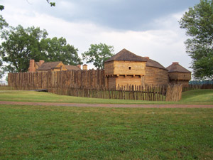
George Rogers Clark Home Site, Falls of the Ohio State Park
Sometimes referred to as Clark’s Point, this is the site where General George Rogers Clark, the “Conqueror of the Northwest” and older brother of William Clark, lived from 1803 until 1809. William, and probably York, lived here with George prior to the departure of the expedition in 1803. It was George Rogers Clark whom Thomas Jefferson first asked to lead an expedition to the Pacific in 1783. From this site Meriwether Lewis, William Clark, and the nucleus of the Corps of Discovery launched their expedition on October 26, 1803. Clarksville is named in honor of George Rogers Clark. Today, a cabin dating from the early 19th century, similar to the original Clark cabin, stands on the site overlooking the Ohio River. The park is a certified site on the Lewis and Clark National Historic Trail. East of the cabin is the park’s Interpretive Center, a short one and one-half mile hike or two mile drive. The Interpretive Center has Lewis and Clark related exhibits and periodically shows the film “Spirit of the Land” about the members of the expedition from the Falls area.
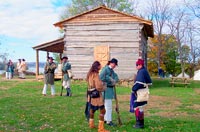
- Location: Harrison Avenue in Clarksville, Indiana, north of the McAlpine Locks and Dam on the Ohio River
- Information: 812-280-9970 / www.fallsoftheohio.org
- Directions: From I-65 take exit 0 and follow the signs onto West Riverside Drive. Turn right on Sherwood Avenue, left on Clark Boulevard, then left on Harrison Avenue to park at the river’s edge.
Floyd’s Station
Site of Floyd’s Station on Beargrass Creek. Sgt. Charles Floyd of the expedition is believed to have been born here circa 1782. The springhouse and Floyd family cemetery still remain.

- Location: A historical marker on Breckenridge Lane at Hillsboro Road marks the approximate spot of the station and memorializes Charles Floyd.
- Information: Beargrass-St. Matthews Historical Society, 502-899-2524
- Directions: From I-264 take Breckenridge Lane north to Hillsboro Rd.
Soldier’s Retreat
A reconstruction of the original house of Clark brother-in-law Col. Richard C. Anderson. Built on the same plan, also present are several of the original outbuildings, including slave cabins and the springhouse, and the family cemetery. William Clark generally made Soldier’s Retreat his first night’s stop when traveling eastward. The house is a private residence and is not open for tours.
- Location: Seaton Springs Pkwy. off of S. Hurstbourne Pkwy.
- Information: Beargrass-St. Matthews Historical Society, 502-899-2524
- Directions: From I-64 take Hurstbourne Pkwy. north to Seaton Springs, turn left. The cemetery and house are immediately on the left.
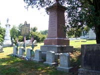
Cave Hill Cemetery
A number of Clark family members are buried here. Among them are George Rogers Clark and Jonathan Clark (Section P, lot 245), William’s daughter Mary Margaret (Section D, lot 20 – Preston lot), and grandsons John O’Fallon Clark (Section O, lot 203 – Zane lot) and Meriwether Lewis Clark, Jr. (Section A, lot 699 – Churchill lot).
- Location: 701 Baxter Ave. at Baxter and Broadway in Louisville
- Information: 502-451-5630, http://www.cavehillcemetery.com
- Directions: From downtown Louisville take Broadway east to Baxter Ave.
Bethany Memorial Cemetery – South Jefferson Cemetery
The possible burial site of Reubin Field of the expedition. He married into the Myrtle family and is believed to have been buried in their family cemetery. That family cemetery was transferred to Bethany due to area development.
- Location: 10917 Dixie Hwy. (U.S. 31-W) at the Gene Snyder Freeway
- Directions: I-65 to Gene Snyder Freeway west, turn north on Dixie Hwy. The cemetery is located at the exit.
Clark Townhouse
John Clark owned a townhouse at 8th and Jefferson Streets in Louisville. William Clark apparently inherited it in 1799. William may have lived here when he visited Louisville, as well as while staying in Louisville to prepare for the expedition.
- Location: Northwest corner of 8th and Jefferson in downtown Louisville.
Fitzhugh and Rose Store
Clark’s brother-in-law Dennis Fitzhugh operated a store in the vicinity of 5th and Main Streets. William Clark shopped there on November 5, 1806, the day he, Lewis, York, and others arrived at the Falls on their return from the expedition. Clark and York made subsequent visits to the store when in Louisville.
- Location: Vicinity of 5th and Main Sts. in downtown Louisville.
Courthouse Square area
William Clark was at the Jefferson County Courthouse the day the Corps departed, October 26, 1803, to file a power of attorney. In 1803, the courthouse was in the vicinity of 6th and Jefferson Sts. in downtown Louisville. In front of the present courthouse are statues of Thomas Jefferson and Louis XVI for whom the county and city are named.

- Location: 6th and Jefferson Sts. in downtown Louisville
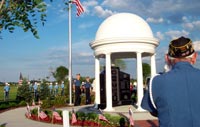
Patriots Peace Memorial
Memorial dedicated in 2002 to honor “the sons and daughters of our region who gave their lives during times of peace for the cause of freedom.” The memorial includes a brick honoring Charles Floyd, a Kentuckian and the only member of the Corps of Discovery to die during the expedition.

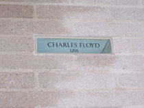
- Location: Next to Thurman-Hutchins Park on River Road east of Zorn Ave., Louisville, Ky.
Kentucky Derby Museum
Located at Churchill Downs, the museum chronicles the history of this historic track and the Kentucky Derby, including information on Meriwether Lewis Clark, Jr., the grandson of William Clark, and the founder of both Churchill Downs and the Kentucky Derby.
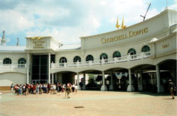
- Location: 704 Central Avenue, Louisville, KY, 40208
- Information: 502-637-7097, www.derbymuseum.org
- Directions: From I-65 take Eastern Parkway west to Third Street. Turn left on Third, then right on Central. From I-264 take Southern Parkway north to Central and turn right; or I-264 to Third Street, north to Central. Turn left.
McAlpine Locks and Dam
Located at the Louisville and Portland Canal, this U.S. Army Corps of Engineers visitor facility overlooks the canal and is in the area of the former town of Shippingport. In 1803, there was no canal. Lewis and Clark hired a pilot to take the keelboat and red pirogue through the Falls to the Clark farm at Clarksville on October 15. They crossed at the foot of the Falls in this area to travel between Clarksville and Louisville while preparing for the expedition. It was at Shippingport that Clark parted from his family in 1808 when he moved to St. Louis.
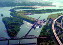
- Location: Northwestern Pkwy. and 27th St.
- Information: 502-315-6767
- Directions: From I-64 take the 22nd St. exit, turn west on Northwestern Pkwy., right on 27th St., follow signs.
Fort Massac State Park
Here Lewis and Clark recruited George Drouillard and an unknown number of soldiers for the expedition. A replica of the fort stands next to the marked outline of the original fort. A small museum of the history of the post is maintained.
- Location: 1308 E. 5th Street, Metropolis, IL 62960
- Information: 618-524-4712
- Directions: From I-24 take US 45 north to Metropolis. Turn left into the park before reaching town.